Seismology at School in Nepal: A Program for Educational and Citizen Seismology Through a Low-Cost Seismic Network
By  Shiba Subedi1*,
  György Hetényi1,
  Paul Denton2† and
  Anne Sauron3

ABSTRACT
Nepal, located above the convergent India-Eurasia plate boundary, has repeatedly experienced devastating earthquakes. During the 2015 magnitude 7.8 Gorkha earthquake, an often-reported experience was that people were not aware of the threatening seismic hazard and had an insufficient level of preparedness. An important source of the problem is that earthquake-related topics are not part of the school curriculum. Earthquake education reaching a broad group of the population early in their lives is therefore strongly needed. We established an initiative in Nepal to introduce seismology in schools, with a focus on education and citizen seismology. We have prepared educational materials adapted to the Nepali school system, which we distributed and also share on our program’s website: http://seismoschoolnp.org. In selected schools, we also installed a low-cost seismometer to record seismicity and to allow learning-by-doing classroom activities. Our approach was very well received and we hope it will help make earthquake-safe communities across Nepal. The seismic sensor which we installed in schools is a Raspberry Shake 1D (RS1D), this was selected based on its performance in laboratory tests and suitability for the field conditions. At a test site in Switzerland we were able to record magnitude 1.0 events up to 50 km distance with a RS1D. In Nepal, 22 such seismometers installed in schools create the Nepal School Seismology Network providing online data openly. The seismometer in each school allows students to be informed of earthquakes, visualize the respective waveforms, and estimate the distance and magnitude of the event. For significant local and regional events, we provide record sections and network instrumental intensity maps on our program’s website. In 6 months of network operation, more than 194 local and teleseismic earthquakes of M ≥ 4 have been recorded. From a local and a global catalog, complemented with our own visual identifications, we have provided an earthquake wave detectability graph in distance and magnitude domain. Based on our observations, we have calibrated a new magnitude equation for Nepal, related to the epicentral distance D [km] and to the observed peak vertical ground velocity PGVV [μm/s]. The calibration is done to best fit local catalog magnitudes, and yields the following equation: M = 1.05 × log10(PGVV) + 1.08 × log10(D) + 0.75.
INTRODUCTION AND BACKGROUND
Nepal is located above the Himalayan convergent plate boundary between the Indian and Eurasian plates (Aitchison et al., 2007), and consequently in the heart of the most active continental seismic hazard zone. The recent geological and geodetic shortening accommodated across the Himalayas is about 2 cm/yr (Bilham et al., 1997; Lavé and Avouac, 2001; Jouanne et al., 2004; Zheng et al., 2017). The surface expression of this shortening is the Main Frontal Thrust, which continues at depth, to about 15 km below the surface, for more than 100 km toward the North, forming the Main Himalayan Thrust (Cattin and Avouac, 2000; Duputel et al., 2016; Elliott et al., 2016). This is the megathrust interface which hosts major earthquakes all along the 2’500 km long Himalayan range. The mountain belt has experienced devastating earthquakes throughout the geological, historical and recent past, claiming lives and causing significant damage. Nepal, in the central part of the Himalaya, occupies nearly one third of the mountain belt, and is the home of ca. 30 million people who live in a very high seismic hazard zone.
The largest instrumentally recorded earthquake in Nepal, the 1934 Mw8.2 event has been followed by the Mw7.8 Gorkha earthquake and a second, Mw7.3 event in 2015 in Central Nepal (Figure 1). Paleoseismic investigations along strike of the active frontal thrust reveal further large historical earthquakes (e.g., Bollinger et al., 2016), the oldest known earthquake described in a primary source having occurred in 1223 (Bollinger et al., 2016), but its description remains unreadable due to defaced letters and words. The greatest event in Nepal, which is also the most recent great earthquake in Western Nepal, occurred in 1505, as reported in historical chronicles (Ambraseys and Jackson, 2003; Ghazoui et al., 2019). The elapsed time since then leads to the existence of a well-identified seismic gap in which another large earthquake is due (Bollinger et al., 2016). This fits the overall view of the seismic cycle in the Himalayas, which has recorded a major earthquake all along the mountain belt in the past 500 years (Hetényi et al., 2016). Earthquakes are the most common and most deadly natural disaster in Nepal, claiming more than 19 thousand lives since 1934, which is more than 80% of the total casualties from natural disasters (Ministry of Home Affairs [Moha], 2015).
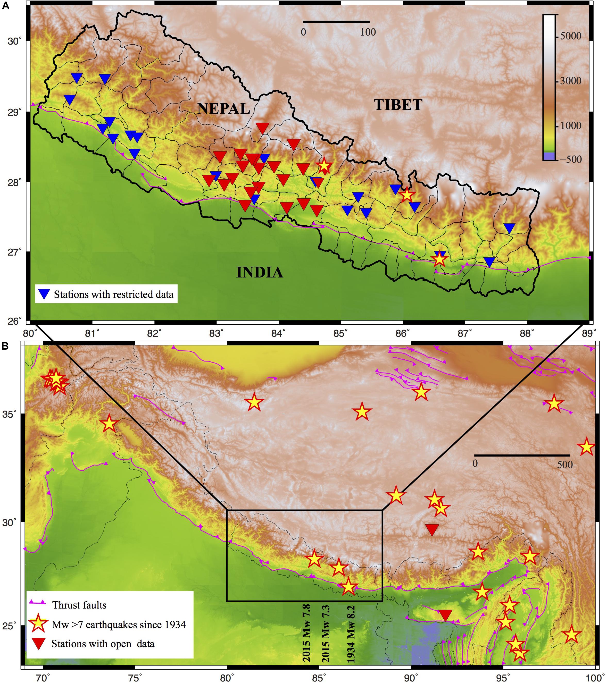
Figure 1. Studied area maps. (B) The Himalaya-Tibet region, with large and great earthquakes (M ≥ 7) since 1934 from the USGS catalog (https://earthquake.usgs.gov/earthquakes/search/). Permanent seismic stations with open data are shown in red. (A) Focus on Nepal, showing 21 permanent seismic stations of the National Seismological Center with restricted data in blue, and 22 Nepal School Seismology Network (this project) stations in Western Nepal with open data in red. Pink lines are thrust faults in the area (Styron et al., 2010). Distance scales are in kilometers.
Despite the clearly high seismic hazard, permanent seismological observatories with open data are rare in the region (Figure 1). The only government facility in Nepal is the National Seismological Center (NSC), which has been operating a permanent seismic network for decades within the framework of international collaboration, and is currently operating 21 short-period and broadband stations in the country. The NSC publishes earthquake information to the population for earthquakes inside Nepal when the local magnitude ML equals or exceeds 4. Other seismic networks in the area are typically temporary research networks, they are installed for a few years, but their data is only openly accessible after a few years of delay and in a format far less comprehensible to the general public.
Scientific results based on these seismological data are abundant and should be acknowledged for pushing the limits of knowledge in an area where fieldwork conditions are not straightforward. Geophysically imaging the structure of the orogen at depth (e.g., Schulte-Pelkum et al., 2005; Nábělek et al., 2009; Singer et al., 2017; Subedi et al., 2018) is very important to establish quantitative models of seismic hazard. Locating the seismicity both during the inter- and the post-seismic periods (e.g., Bollinger et al., 2007; Adhikari et al., 2015; Diehl et al., 2017; Hoste-Colomer et al., 2018) are equally important to understand the mechanical behavior and dynamics of the orogenic wedge. Nevertheless, state-of-the-art geoscience knowledge reaches only a very small fraction of the population. For example, recent publications report that there is an increased risk of a future major (M > 8) earthquake in the area between west of Nepal and India (Galetzka et al., 2015; Avouac et al., 2015), and recent estimates of average return period for great earthquakes ranges from 300 to 870 years plus uncertainties (Avouac et al., 2001; Bollinger et al., 2014). However, the local population has almost no information about these recent findings.
What the local population is aware of are their own felt-earthquake experiences, the fresh memory of the 2015 Gorkha earthquakes, and the announcements of the NSC (ML ≥ 4 events in Nepal). The latter information is spread through the NSC webpage1, through social media, and – with some time lag – through newspapers and online articles. Still, the general level of information about what a person should do in case of a seismic event is surprisingly low. Citizen’s awareness is a key element for seismic risk mitigation, which is clearly missing in the field. Some efforts by various organizations after the 2015 Gorkha earthquake around the capital city Kathmandu were initiated, but these have not reached people in the countryside. The majority of Nepal’s population has either a mythological perception or no clear idea about what causes earthquakes and what is the best behavior and practice to protect themselves. In addition, ways to communicate about earthquakes and related topics are not well established in the community.
Our initiative aims to tackle two challenges with a combined approach, for which we start our program in an area of high seismic hazard but relatively limited (although not the lowest) level of information in the country. First, it is crucial to increase the awareness of the local population about the fact that they live in a region where the accumulated energy is sufficient to produce a large earthquake. Second, we need to teach and train citizens in the community for better preparedness and what actions they can undertake to lower their chances of being hurt. In the countryside, no other source of information like television and newspapers are easily accessible, and also in cities it is difficult to gather knowledge from these kinds of sources. Hence, we found that the best way to engage people in learning about earthquakes is through the educational system, as what information students receive at school can be transmitted to their families and communities most efficiently.
In order to undertake this approach, it is necessary to connect communities to citizen science in Nepal. That is why we installed the first 22 low-cost seismic stations in local schools as a part of the Nepal School Seismological Network (Figure 1). This network is already used both for teaching and for sharing locally recorded data openly. We hope that the example set in Western Nepal will spread across the entire country, and that our program helps to make earthquake-safer communities.
Although the most obvious way to involve citizen to Earth sciences is to share information about the local effects of natural seismicity, other forms of involvement can be explored. We propose here to focus the attention on secondary schools students by installing seismometers in their centers and involve the students in their management, with the ultimate goal of developing their curiosity about the sources of the recorded vibrations and, in general, providing hypotheses to explain data.
We are convinced that this can be a positive approach to increase the interest of society toward Earth sciences, in particular in countries not often affected by large earthquakes. The presence of Earth sciences in the curricula of secondary education has been decreasing in recent years in Spain and we believe it is urgent to promote actions to attract students’ attention to this field.
Our experience has shown that we can have a relatively high impact on social networks (Twitter, Facebook, Instagram) and mass media by unraveling and making the public aware that seismic sensors can detect activities such as traffic, subway trains or citizen activities as football games, music concerts or fireworks. We believe that attracting the attention of the public is of maximum interest for the future of our research field.
In addition to these aspects related to dissemination, we expect that data obtained by citizen networks installed in educational centers within the city of Barcelona can be useful from a scientific point of view, as the characterization of the sources of background vibrations in urban environments is of great interest to study the seismic structure beneath pavements and buildings using ambient noise data and hence make possible a better imaging of the geology beneath the city and an improving of the available seismic hazard maps.
Read the rest of the report from Shiba Subedi, et al. and published at Frontiers in Earth Science.
From all of us at Raspberry Shake we would like to thank each of the authors of this paper.