
URUGUAY BECOMES EARTHQUAKE AWARE WITH RASPBERRY SHAKES
December 19, 2022 – by Enrique Latorres and Leda Sánchez. http://ogu.fcien.edu.uy

Summary
Uruguay is in an intraplate zone. It has a low probability of significant earthquakes. Also Uruguay has a low population density and the population is concentrated in a few cities. So historically there are very few records of earthquakes.
There was a widespread belief that Uruguay was Earthquake-free. Uruguay did not have a single seismograph until 2013 when we installed the first one. There are now more than 20 stations installed. The Geophysical Observatory of Uruguay (OGU) was created in 2010, after the news of the Haiti earthquake. We wondered if something like this could also occur in Uruguay and because of this, we did a study of library and newspaper records on seismic events in Uruguay. We found records of few but significant events in the region. We came to the conclusion that if a similar event occurred to these, it could be a danger for buildings and people in the area. From this point forwards, the OGU has gained knowledge and created a network of sensors where Raspberry Shakes play an important role in network densification, to register micro-seismicity in the region. We have increased the number of stations with recent acquisitions of Raspberry Shakes and Raspberry Boom models, to monitor earthquakes, quarry explosions and thunderstorms.

OGU’S Network of Seismic Stations
Introduction
The objective of the Geophysical Observatory of Uruguay (OGU) is to monitor the seismic activity of the national territory, as well as research in other areas of Geophysics (paleomagnetism, artisanal and small-scale mining, geophysical prospecting, among others).
In collaboration with several governmental agencies, it is responsible for communication and prompt response on seismic events that occur in the region.
The OGU consists of a small but very committed team that provides services to society both in the face of natural events and those induced by human activities, disseminating scientific knowledge about the geological and tectonic characteristics of our territory.
Historical background
Uruguay has a young history. We assume its recorded “History” began with the English invasion where for a short period in 1807 Montevideo and the surrounding area were part of the British Empire. It was at this point for the first time a newspaper called the “Southern Star”-“EstrelIa del Sur”, was created in both English and Spanish (Zinny, 1883), and local news was recorded with written public records. Before that, the Spanish government prohibited and penalized any type of unauthorized written communication (Acree, 2007) (Villa and Fernandez, 1995). Even many government records were then shipped to Madrid. Therefore, there are very few relevant records from colonial times.
The English invasion of Montevideo also showed the weakness of the Spanish empire and demonstrated that the locals could organize and defend themselves without depending on the monarchy. But the significant thing for us is that there are no important official records before that date other than some in Spanish archives. This includes a lack of seismicity records.
Uruguay is in an intraplate zone. It has a low probability of significant earthquakes. Also, Uruguay has a low population density and the population is concentrated in just a few cities. Most earthquakes that occur are of very low intensity, meaning that few earthquakes are perceived by the population. Added to the lack of historical records, earthquakes in the territory were not perceived as such. Due to the particular characteristics of the few earthquakes which were felt, generally of shallow depth, many confused them with thunder, sky quakes, army explosions, or other atmospheric effects. Even the government advertised the non-existence of earthquakes in Uruguayan territory (Subrayado, 2014) until a few years ago.
Also because of this Uruguay never had a seismograph until the OGU installed the first one in 2013.
Our interest in the subject was motivated after the Haiti earthquake on January 12, 2010. After this earthquake, the country was destroyed and has still not completely recovered after more than 12 years after the disaster, and unfortunately remains a dysfunctional nation to this day.

Paso de los Toros’s Stations(PDTT) Tacuarembó R2EE0
Research
We asked ourselves whether something similar could happen to Uruguay. We know that Uruguay has earthquakes, and the studies of Benavídez (Benavídez, 1998) on historical records of seismicity showed that indeed Uruguay is not safe from significant earthquakes. Benavídez suggests in his article that the earthquake of August 9, 1848 was “the first historical record of seismicity in the Uruguayan territory since the first settlements in the territory (in the middle of the XVII century)”. Four years later, on June 5, 1888, another earthquake of probably greater magnitude occurred, which caused alarm among the population of the Río de la Plata region.
At that time there were no significant material losses, nor was there any loss of life. But the buildings were mostly one-story buildings, with light roofs and thick brick walls. And the few taller buildings were structures designed and built by European architects, in monumental style, using standards and customs of their countries. Very solid and robust construction.
But today’s Uruguay, of financial and technological services, has tall buildings of almost transparent structures in concrete, iron and glass. These were built by many architects and engineers with the belief that there are no earthquakes in Uruguay.
Perhaps the first historical record was written by Alvar Núñez Cabeza de Vaca (1555). A group of Spaniards leaving Buenos Aires and on their way to Asunción in 1542, on what would be the current coast of Colonia, in Uruguay, in the ravines near the mouth of the San Juan River, experienced an earthquake and probably a seiche that caused the death of at least fourteen people.
Attempting the re-foundation of Buenos Aires, after the evacuation of the city of Buenos Aires in 1541 (Schávelzon, 2006), a second attempt was made by Gonzalo de Mendoza in 1542 to re-found the city. But the harsh winter made it difficult, so they decided to return to Asunción. On the way, they anchored on the coast of Uruguay, at the mouth of the San Juan River, Colonia, with its coastal ravines.

Seism Recording in Uruguay
On Saturday, October 31, 1542, the eve of All Saints’ Day, something disastrous happened to Captain Gonçalo de Mendoça. He lost a ship loaded with merchandise and supplies and many people died. He writes that while they were sailing something strange happened. On that eve his ships were anchored on the river bank. Among them was a galley tied to a tree. He says that the earth shook, and the earth itself came down like a blow from the sea into the ravine.he trees fell into the river, and the ravine hit the brigantines, and the tree where the galley was moored gave such a strong blow to the galley that it pushed the ship upside down. And so she was dragged more than half a league (two kilometers approximately), with the mast underneath and the keel on top. In this event, fourteen people, including men and women, drowned in the galley and the other boats.
It is difficult to estimate the magnitude of the earthquake from this information, but it is surely the strongest earthquake ever recorded in the region.
And if it happened once, one of similar magnitude may happen again. The fact that at least fourteen people died, in an open field, at a time when the region was practically unpopulated, speaks of the importance of this event.
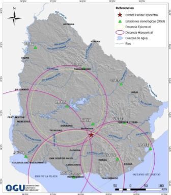
Epicenter location for Montecoral’s seism, Florida, Uruguay
Creation of the observatory
These events, along with the earthquake in Haiti, motivated us to carry out more complete studies and create a research laboratory. The primary aim was to understand and predict the seismic risk of the Uruguayan territory (Baxter et al., 2021) while at the same time promoting the use of geophysical methods and models for earth science research in Uruguay.
Since 2010 onwards, efforts and actions were done to create what is today the Geophysical Observatory of Uruguay (OGU), Faculty of Sciences (UDELAR). Cooperation was sought with other universities to help form the team and obtain the necessary knowledge to carry out the activities and research.
Our first successful contact was with Dr. Marcelo Sousa de Assumpção, Department of Geophysics, Institute of Astronomy, Geophysics and Atmospheric Sciences,
University of São Paulo (USP). In 2013, with a cooperation agreement with USP we installed the first seismograph in Uruguay, at the premises of the Aiguá Geophysical Observatory, a station near Cerro Catedral, the highest point in Uruguay, in the Department of Lavalleja, where we had already installed a geomagnetic observatory. This allowed us to start seismological monitoring in Uruguay.
Starting in 2016, we developed a small network of accelerometers and seismometers. With a lot of effort, and some support from the University of the Republic (UdelaR), Comisión Sectorial de Investigación Científica (CSIC) and the Government, collaborations with several Uruguayan State Institutes, several foreign organizations and universities, and a lot of personal investment, in nine years we developed a network of geophysical sensors that includes mainly seismometers and accelerometers in more than 20 facilities spread throughout the country. And we also included several magnetometers, a riometer, an all-sky camera, among others.
We also have the collaboration of the Ministry of Defense, the National Army, the Military Geographic Institute and the Uruguayan Antarctic Institute. In addition we have the support of the Ministry of Interior and National Police, the Ministry of Industry and Energy and the National Directorate of Mining and Geology. Our members are from University la República, University ORT Uruguay and other affiliations.
The Observatory also participates in numerous scientific dissemination activities, giving lectures or courses to those who request them. We participate in educational talks about the seismicity of the region and seismic risk with schools, high schools and teacher training institutes in Uruguay.
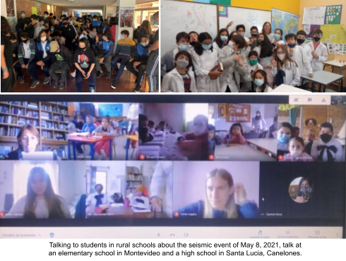
Talking to students in rural schools about the seismic event of May 8, 2021, talk at an elementary school in Montevideo and high school in Santa Lucia, Canelones.
One of our objectives is to identify faults and zones of possible seismogenesis. And from this develop a risk map, and suggest construction standards that can prevent the risks associated with the occurrence of earthquakes in the future. This implies studying low intensity earthquakes in the territory, in order to be able to estimate the maximum seismicity that may occur.

Antarctic Scientific Base Artigas (King George Island, Uruguay)
Raspberry Shake for Network Densification
An alternative to increase the density of sensors in the territory at low cost was the use of Raspberry Shake. The first one was acquired in 2018. Today we have 8 Raspberry Shake 3D’s installed in various locations with another Raspberry Shake and a Raspberry Boom on the way. Others are expected to be installed in the near future. In March 2020, one was installed permanently at the Artigas Antarctic Scientific Base (Uruguay) located on King George Island. As these instruments are economically accessible, they have allowed us to expand the national network significantly.
")
These events, along with the earthquake in Haiti, motivated us to carry out more complete studies and create a research laboratory. The primary aim was to understand and predict the seismic risk of the Uruguayan territory (Baxter et al., 2021) while at the same time promoting the use of geophysical methods and models for earth science research in Uruguay.
Since 2010 onwards, efforts and actions were done to create what is today the Geophysical Observatory of Uruguay (OGU), Faculty of Sciences (UDELAR). Cooperation was sought with other universities to help form the team and obtain the necessary knowledge to carry out the activities and research.
We are currently studying the microseismicity induced by a dam with Raspberry Shake 3D sensors installed near the site.
The seismic stations are set following the installation protocols proposed by IASPEI, adjusted to the characteristics of our territory.
During the COVID pandemic, the only equipment that remained in operation were the Raspberry Shake 3D’s. Thanks to them it was possible to identify the most important event that has occurred in Uruguay over the last decades (ML= 4.7) and also more than 20,000 events that have occurred in the Bransfield basin in the Antarctic zone.
The installations almost always consist of a concrete slab on which are placed prefabricated reinforced concrete chambers, usually 60 cm wide, and 60 or 40 cm high, with frame, cover and upper back cover. One of the chambers is for the sensor and the other is for telecommunications, electrical power, charger, batteries and surge protection. Internally they are painted with cold polyurea, to insulate from humidity, and then covered with soil and gravel.

Conclusions
The incorporation of the Raspberry Shake 3D’s into our network has allowed us to increase the density of sensors in the national territory, and to also include our base in Antarctica and to carry out several research studies with low cost and high availability data.
We expect to continue adding more equipment, in particular “Shake & Boom” models for monitoring explosions, storms, electrical discharges and shallow seismic events, in the near future.

References
Acree, W. “La otra batalla: The Southern Star, la Gazeta de Montevideo y la revolución de las formas de comunicación en el Plata”. En Frega, A. y Vegh, B. (eds.), En torno a las “invasiones inglesas”: relaciones políticas y culturales con Gran Bretaña a los largo de
dos siglos. Montevideo: Facultad de Humanidades y Ciencias de la Educación – UdelaR (2007): 13-22.
https://anaforas.fic.edu.uy/jspui/bitstream/123456789/37146/3/Acree_SobreEstrellaSurrev.pdf
Baxter,P.; Sánchez Bettucci, L.; Costa, C.H.; Assessing the earthquake hazard around the Río de la Plata estuary (Argentina and Uruguay): Implications for risk assessment; Journal of South American Earth Sciences, Volume 112, Part 1, December 2021, 103509. https://doi.org/10.1016/j.jsames.2021.103509
Benavídez Sosa, Alberto; “Sismicidad y sismotectónica en Uruguay”; Física de la Tierra; 1998, n.’ 10: 167-186. 155N: 0214-4557.
https://revistas.ucm.es/index.php/FITE/article/download/FITE9898110167A/12147
Castellanos, Alfredo r.; “Montevideo EN El SIGLO XIX”. LA “CIUDAD NOVÍSIMA” pp. 14-21. (1971) Editorial Nuestra Tierra.
http://www.periodicas.edu.uy/o/Nuestra_tierra/pdfs/3-Montevideo_en_el_siglo_XIX.pdf
Núñez Cabeza de Vaca, Alvar,”Relación de los naufragios y comentarios de Alvar Núñez Cabeza de Vaca. Tomo 1″; 1555, Alicante : Biblioteca Virtual Miguel de Cervantes, 2017. pp.245-246 final del “Capitulo Treinta y Siete: De como los indios de la tierra se tornaron a ofrescer”. https://www.cervantesvirtual.com/nd/ark:/59851/bmch1534 Una reimp. de la ed. publ. en Valladolid en 1555 con el título: La relación y comentarios del gobernador Alvar Núñez Cabeza de Vaca, de los acaescido en las jornadas que hizo a las Indias. Edición digital a partir de Madrid, Librería General de Victoriano Suárez, 1906 (Colección de libros y documentos referentes a la historia de América ; t. 5)
Schávelzon, Daniel; El Asiento de la Primera Buenos Aires: Entre la Historia y el Mito. 2006. Centro de Arqueología Urbana. Instituto de Arte Americano e Investigaciones Estéticas “Mario J. Buschiazzo”. Facultad de Arquitectura, Diseño y Urbanismo. Universidad de Buenos Aires. http://www.iaa.fadu.uba.ar/cau/ebooks/1absas/Fundacion-1a-BsAs.pdf
Subrayado, 28 de enero de 2014, 19:19hs; Impactante campaña para evitar accidentes en Uruguay; https://www.subrayado.com.uy/impactante-campana-evitar-accidentes-uruguay-n30417
Villa, Óscar Jorge; Fernández, Alicia; “REVOLUCIÓN, PRENSA Y PROPAGANDA EN EL RÍO DE LA PLATA (1810-1815)”, en “Deslindes”. Revista de la Biblioteca Nacional, nº 4-5; Biblioteca Nacional, (1995-12) ISSN 0797-6402
http://anaforas.fic.edu.uy/jspui/handle/123456789/30687
Zinny, Antonio; “Historia de la prensa periódica de la República Oriental del Uruguay, 1807-1852”; 1883. https://anaforas.fic.edu.uy/jspui/handle/123456789/5703